Having reached the northern and western extremes for the trip, I was now headed towards the rising sun and away from the Great White North. But, enjoying cross-cultural experiences as I do, and not wanting to backtrack over roads I’d already travelled, I headed east across British Columbia instead of back down to Seattle when I left Chad’s house on the morning of day number 20 of the expedition. Heading across Canada’s Highway 1 I waved at Chilliwack and Langley as the friends I have from there weren’t around, and realized from the smell that this was an agricultural and livestock dominated area. It reminded me of home.

Going east across BC, I was amazed at the mountains and how they kept opening up before me. A two-lane road (Highway 3B... why the B, I don't know) that twisted and turned was a great way to get back into the routine of driving after a 7 day stretch of riding only 670 miles. The road meandered beside rivers, twisted and turned through valleys, and led me across unspoilt landscapes. I passed large fields of crops, virgin forests, and orchards full of fruits. After several hundred miles, sometime in the early afternoon, I crossed back into the land of Chevrolet, hot dogs, and apple pie in Northeastern Washington. The journey down towards Spokane was nearly as scenic as BC, but it didn’t take long to hit suburbs and places that showed I was clearly not in Canada anymore. From there I tried to push it and make it to Western Montana before too late in the night as I was hoping to meet up with my friend Josh from TU who works with Camp Bighorn.
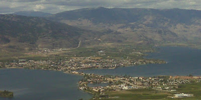
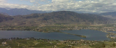
Osooyos, Canada
Camp Bighorn facilitates a group of students every year from Prairie Bible College in Alberta in which they Explore and Discover God in nature. It provides a Scriptural foundation to leadership and wilderness training. The day I was hoping to arrive was the last of a 4 day camping excursion which Josh was helping to lead. They were camping somewhere in the middle of the woods, and I intended to find them. I had been enjoying my ride during the day, but knew that it was far to get to the campsite, so while I didn’t delay, with the loss of an hour through entering into the mountain time zone, and taking some time to enjoy the beauty of the creation around me on the motorcycle, it looked like I was going to be getting to the area Josh explained they’d be around 8:30pm. He had a cell phone, but it didn’t get reception at the campsite itself, and the site was 20 miles down a forestry service road. But, with Josh’s directions, in spite of the realization I’d be arriving after dark, I was confident it wouldn’t be a problem.
So, what I thought would be an arrival of around 8:30 turned into just getting to the Montana border around that time and off the exit that would lead to the campsite at around 9pm. The forestry service roads aren’t really all that well labelled either. And after about 40 minutes of back and forth to the exit and up and back a few random dirt roads near the exit and to the gas station right at the exit, I settled on a road that the kind lady at the station convinced me was the one I wanted. After about 45 minutes of driving in complete darkness through a single lane gravel road up and down through the mountains of Western Montana, I arrived at the campsite sometime shortly after 10pm. It was actually quite a fun ride that reminded me at times of driving the little Yamaha AG 100 motorbike across the much worse dirt roads of Liberia. In this instance, however, I only slid the back end of the bike a few times when locking the brakes as I realized I was coming too fast into turns that I couldn’t tell at all how sharp they were in the utter darkness. It was a thrilling end to the 600+ miles I travelled this day, though, and it was such a joy to get to see Josh again after 3 years or so of only sporadic emails.

Although it was early in September, I learned when I arrived that the morning of the night I had arrived Josh and the others all awoke to find the ground covered in white. It had snowed that morning. And here I am camping outside in the woods. I wasn’t prepared for such cold weather, but thankfully Josh had an extra sleeping bag, blanket, and jacket that I was able to use. The next morning we travelled to Camp Bighorn where I relaxed for the rest of the afternoon, floating on the river through some small rapids, and then enjoyed a trip to “town” which was the tiny village of maybe 1,500 people of Plains, Montana. There was a grocery store, a gas station, and a casino. I think that was it. But the camp was tucked away at the base of a rocky cliff and on the banks of a sinewy river. It was a fabulous place to spend a day, cook some steaks, and relax with an old and several new friends. And, as I was to realize the following day, it was the last place to really enjoy the beauty of the mountains and take in the most dramatic of the scenery I was to experience for the journey. For Eastern Montana, North Dakota, South Dakota, and Minnesota are 1,300 miles of empty, open nothingness. But even that couldn’t take away from what I’d already experienced thus far on the journey.
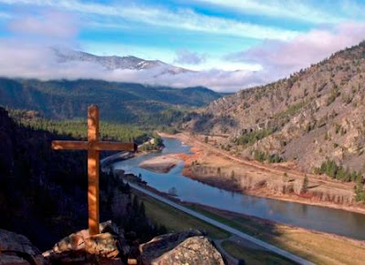
Above Bighorn

1 comment:
Beautiful photos - amazing journey - loving it!
Praying for you Jeff...
Mel (almost-Ewert)
Post a Comment